TAKING FLIGHT. Grand Marsh, Wis., strip-tillers Eric and Megan Wallendal’s investment in an unmanned aerial vehicle (UAV) helped them make adaptive decisions for in-season nutrient application and for their variable-rate irrigation program.
The motor begins to hum and the propellers begin their increasingly rapid revolutions. A gentle upward tilt of the joystick by the owner and the rotocopter is airborne — slowly elevating as it drifts over a cornfield to capture hundreds of images that will be processed and analyzed.
This was a recurring practice last year for Eric and Megan Wallendal on their family’s 3,200-acre farm in Grand Marsh, Wis. The husband and wife are among a growing number of farmers experimenting with and applying unmanned aerial vehicle (UAV) technology on their operations.
But as agricultural interest in UAVs, or drones, has increased dramatically in the last few years, so too have the number of questions about the practical payback and tangible benefits these tools can provide to farmers.
“I think there’s a lot of misconception out there that farmers can fly a drone and it will immediately provide a solution to a problem,” Eric says. “It’s still trial and error, but we’ve found that the technology gives us a better tool to analyze what’s going on in the field during the growing season, and also project ending results to manipulate future cropping practices.”
You May Also Be Interested In...
Putting Precision Practices to Work in Strip-Till
The benefits of incorporating precision practices into everyday farming have yielded excellent results for strip-tillers worldwide. Strip-Till Farmer has collaborated with strip-till experts to provide you with a FREE 17-page eGuide, “Putting Precision Practices to Work in Strip-Till.” This special, in-depth eGuide is designed to arm you with dozens of tips and tricks on choosing and incorporating farming strategies that can enhance your strip-till results. Download now »
Analysis of high-resolution imagery collected from their UAV system, in conjunction with variable-rate fertilization, irrigation and soil testing, lead the Wallendals to estimate a $20 per acre profit on 850 acres of silage corn, and a $5-$10 savings on application costs on 750 acres of soybeans in their first year with the precision tool.
Getting Off the Ground

“The importance of having NDVI images for us was to get an in-season picture of crop health at our fingertips…”
— Megan Wallendal
Thorough research and setting attainable goals were the first steps for the Wallendals in selecting the right UAV for their farm. Two key features they wanted were ownership of the software and Normalized Difference Vegetation Index (NDVI)-quality images.
After researching nearly 20 companies, they purchased a $25,000 Pacesetter system from Indiana-based Precision Drone, which includes a software stitching license from Agisoft, a Russian technology developer.
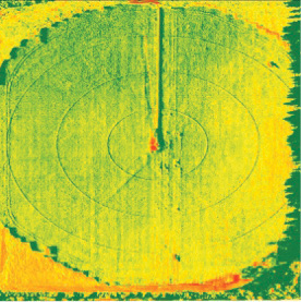
The rotocopter has two mounted cameras: one that captures red, green and blue (RGB) images and the other captures near-infrared images.
“The importance of having NDVI images for us was to get an in-season picture of crop health at our fingertips,” Megan says. “It was a substantial upfront cost, but for a 160-acre field, we can collect 1,600 images and, rather than spend up to $10 per acre to have them stitched together by a third party, I preferred to learn to stitch the images together myself.
“It’s not that difficult to do and I can process images for a 160 acre field in about an hour.”
This allows the Wallendals to make quicker, more informed management decisions on their operation. Farming in primarily sandy topsoils with light clay underneath, preserving water and fertilizer has long been a challenge for them. With largely stagnant organic-matter content between 0.7% and 1%, they leverage strip-till and other practices to help preserve soil health and increase crop yields.
Their operation includes a diverse rotation of silage corn, snap beans, soybeans, kidney beans and alfalfa. They also grow forage corn for a sizeable dairy operation and rent out about 800 acres for potatoes.
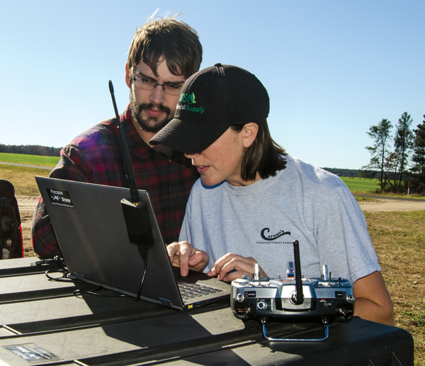 |
| MAKING DECISIONS. When deciding what type of UAV they wanted, the Wallendals had two criteria: ownership of the software and availability of Normalized Difference Vegetation Index-quality images so they can make more informed nutrient application and planting decisions. |
Megan says they are “guerilla farmers” because they partner with canning companies to grow the crop of choice any given season.
One of their initial goals with the UAV, was to better track production of their specialty crops. While they can use traditional yield monitors for corn and soybeans, it’s harder to historically track yields for potatoes or snap beans. They also have their forage corn custom harvested and, more often than not, the combine doesn’t have a calibrated yield monitor, or any yield monitor at all, Eric says.
“If we’re lucky, we might get reliable yield data 2 out of every 5 years,” he says. “So we wanted to find an alternative method to create our own maps and build some historical data.”
Flying their UAV at 200 feet, Eric says the unit can record stand counts and at about 366 feet, can capture the NDVI imagery to overlay with their soil maps. They also use Veris carts and soil moisture probes to record organic matter, pH levels and water-holding capacity in their soils.
During the growing season, Megan flew some fields at least once per week to capture and compare plant development. This was especially valuable to monitor yield potential in a short-season crop like green beans.
“Using NDVI imagery and our soil electrical conductivity (EC) maps, we were able to identify our healthier plants on the heavier soils and less-healthy plants on the light soils,” Megan says. “What we learned with a 55-day green bean crop is when we saw higher, healthier plants on a heavier soil, we need to plan on planting higher populations in those areas of the field because that’s where our greatest yield potential is going to be.”
Practical Application

“We’re looking at 10% of the cost with our UAV system to verify that we’re using our $150,000 variable-rate irrigation investment correctly…”
— Eric Wallendal
Another goal the Wallendals achieved during their first year of UAV use was applying the imagery to identify and react to in-season nutrient deficiencies. All of their strip-tilled acres are under center-pivot irrigation, and NDVI analysis allowed them to adjust in-season water application.
Working with a local irrigation dealer, the Wallendals have begun to write their own variable-rate irrigation prescriptions to better assess water needs in specific strip-tilled fields, rather than arbitrarily applying water.
“Having detailed imagery helps us verify that we’re using the right prescriptions,” Megan says. “For example, we have a creek that runs through one of our fields where some of our soils would constantly get drowned out. Based off the aerial imagery, we adjusted the prescription so that every 2 degrees, the sprinklers would turn off.”
This adjustment created less runoff into the creek and allowed them to decrease the amount of potash they typically apply in heavier soils near their waterways.
“It’s hard to put an exact dollar amount on what that $25,000 investment in the UAV system has meant for our irrigation program,” Eric says. “But when we have a $150,000 investment in variable-rate irrigation, and if those images are telling us that we’re mismanaging application, that’s pretty economical. We’re looking at 10% of the cost in order to verify that we’re using our larger investment correctly.”
Return on investment has been more quantifiable when it comes to using UAV imagery to fine-tune their nutrient management practices. This past year, they conducted several trials on their silage corn to see what they could learn from UAV imagery and how to apply it to their fertigation program.
UAV Rules: What to Know Before You FlyWhile momentum continues to build for application of UAVs in agriculture, understanding government rules and guidelines is critical before taking flight with the technology. The Federal Aviation Administration (FAA) has two classifications for operation of UAVs. The first is as a “hobbyist,” which doesn’t require FAA certification but requires registration of unmanned aircraft weighing more than a ½ pound and less than 55 pounds. Other restrictions include flying below 400 feet and a requirement that operators maintain constant line of sight with the UAV. The second option is to apply for a commercial exemption and obtain a pilot’s license, which allows operators to use imagery or analysis for business purposes. The FAA is still developing permanent guidelines and registration procedures for commercial operation. This is the category where farmers looking to make management decisions on their farm with UAVs will fall, according to Robert Blair, vice president of agriculture for Measure, a national drone service company. He’s spent nearly a decade flying UAVs on his Kendrick, Idaho, farm and serving as a consultant, but suspects that most farmers are unaware of the rules or ramifications associated with UAVs. “My word of caution to farmers is that if you don’t have an exemption and a license, then you are opening yourself up to liability issues,” Blair says. “If you are utilizing that data to support your farming operation, you are vulnerable to not only a potential lawsuit, but a fine from the FAA.” This is something that Eric and Megan Wallendal have taken into consideration as they plan to expand use of their UAV system on their 3,200-acre operation in Grand Marsh, Wis. While they’ve operated under hobbyist guidelines, they’re applying for an exemption with the FAA with the hopes of eventually offering flight services to neighboring farms. “Once we get a license and exemption from the FAA, we’re hoping to offer the service for $3-$4 per acre,” he says. “We definitely think there is a market.” But to legally and safely take advantage of the opportunities to utilize UAVs, farmers should do their homework first. There is no cost to apply for an FAA exemption and, according to the agency’s website, requests should be made 120 days in advance of the date needed for field operations. |
Making as many a seven nitrogen (N) applications throughout the season, they typically band a starter fertilizer blend of potassium, phosphorus, boron and sulfur 4 inches deep with their two 12-row Orthman 1tRIPr strip-till rigs in spring.
At V3 they broadcast 100 pounds per acre of ammonium sulfate (AMS) and fertigate another 60 pounds per acre of N at V8 or V10.
This past year, once their 850 acres of strip-tilled silage corn started getting close to canopy — about V4 or V5 stage — they flew the UAV to scout plant and field health. Flying at an average elevation of 366 feet, they noticed nutrient variances that correlated with their EC maps.
Putting “boots on the ground” to scout, the Wallendals confirmed that an area of the field was at least a leaf stage behind. They adjusted their in-season variable-rate fertigation prescription based on imagery that had revealed the imbalance in crop health, which they admit would have been difficult to detect without the aerial information.
On one half, they increased N application by 10% and then scaled back application on the other half by the same percentage.
“When I flew the field 8 days later, the entire field was even in terms of health,” Megan says. “It was one of those pictures you want to see of your farm. I went out and scouted it and it was amazing to see the difference.”
Figuring they had balanced out the nutrient levels, the Wallendals’ next N application stuck to their flat-rate fertigation program. But the next batch of images showed a deficiency again, and the field area where they made that extra application ended up yielding about a ton-and-a-half less.
“We don’t know what the maximum yield potential of that deficient side is or if we decreased the yield on the other side, which is why in the future we want to have a controlled area,” Eric says. “Rather than reallocating N to see if that’s a higher-yielding area, maybe we didn’t have to reallocate. Maybe it needed less to begin with and we could have just applied less to the entire field.”
Stitching Together Profit
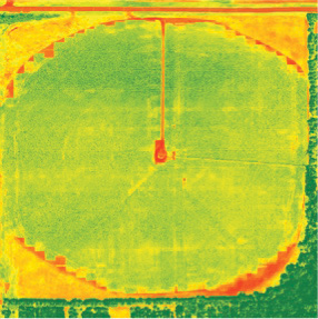 |
 |
| ACTIONABLE IMAGERY. Normalized Difference Vegetation Index (NDVI) imagery collected by Megan and Eric Wallendal’s UAV in 2015 allowed them to reallocate a 10% in-season application of nitrogen through their center pivots. The image on the left shows the silage corn field before the application. The one on the right was taken 8 days later and shows more balanced health throughout the field. | |
While the Wallendals are in the early stages of using UAV data to make long-term farm management decisions, their integration of imagery into their current practices directly contributed to increased corn yield, profit per acre and input cost savings.
On one of the fields where they variable-rate applied N, they only had a 0.3-ton difference between some high EC and low EC soils, based on an evaluation of NDVI images and soil test maps. In other fields where they applied a straight rate of N, they had about a 2-ton yield difference in the field.
Eric admits that there’s still more work to be done to see how they can maximize high-EC soils and what the economic minimum is on the low soils. But at least they know there is a strong correlation between nutrient management and looking at NDVI imagery analysis.
“When we did our yield analysis at the end of the year, we found the biggest return from our UAV data came on our silage corn acres and soybeans,” Eric says. “Besides some of the intangible value, we attributed a $20-per-acre profit to our silage corn because of our ability to detect and react to nutrient deficiencies more quickly.
“For our soybeans we’re able to reduce the number of applications, specifically with having to treat our crops for white mold, because the aerial imagery we collected showed it wasn’t needed. That saved us about $10 per acre.”
In the future, he hopes to use NDVI data collected with the UAV to influence hybrid selection, planting population rates and furthering their variable-rate application program.
“We’re definitely doing variable-rate planting based on soil test management zones, and altering our fertility practices to determine what the minimum and maximum fertility we can apply to stress the plant in either direction,” he says. “We find that each soil type has to be treated differently, rather than treating each crop differently.”
Rather than shooting for 300 bushel corn across the field, Eric says it’s going to be more efficient to shoot for 300 in some areas, but closer to 220 bushels in others because it’s not going to make sense to put on extra units of N and lower the overall economic return.
Megan adds that their crop diversity and soil variability gives them an opportunity for further experimentation with UAV data. One of her goals is to have the imagery serve as a “health check” for their crops throughout the year.
“That would be a huge benefit to us to be able to figure out what’s going on in the field, hopefully fix it, and more efficiently plan for the next year,” she says. “UAVs are one of those tools that become addicting and I don’t know how we’d ever go back to not having this type of data on our farm.”
Want to learn more about the Eric and Megan Wallendal’s experience flying an unmanned aerial vehicle on their farm? Click here to watch a video of them demonstrating their UAV system.