
Most farmers are thankful for the soil and other natural resources they have been blessed with. Farming in Southeast Minnesota is pretty good, owing to the rich soils that Nature has provided.
Minnesota has a large area of some of the best farmland in the world that lies in the Minnesota River Watershed. For decades this rich area has been one of the most tilled areas in the Upper Midwest. A drive in the fall, after harvest, along Interstate 90 from Rochester to Worthington on the western border reveals that virtually every field is turned black. Tillage is rampant!
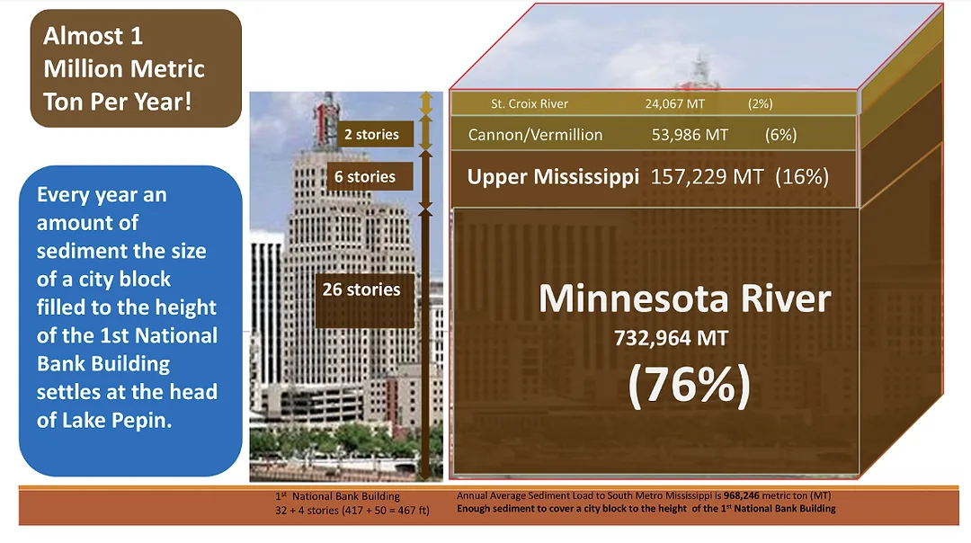
The effects of tillage and the incumbent erosion is not always visible. The Minnesota River drains most of this rich area and is the conduit for carrying away the eroded soil and nutrients. Scientists have studied and quantified the sediment transport in the Minnesota River for many years. The Minnesota River carries its load of sediment into the Mississippi River at St. Paul. At that point, science has determined that 732,964 metric tons per year, enough sediment to fill a city block 26 stories deep, is delivered to the Mississippi each year.
From that confluence the sediment is carried to a wide spot in the Mississippi known as Lake Pepin. The lake has been filling in at an alarming rate since settlement began. With no anthropogenic causes and only natural in-filling, Lake Pepin should remain a lake for about 3,000 years. At the rate sediment is being contributed to the lake, it’s estimated that in about 340 years Lake Pepin will be a wet prairie with a stream running through it.
Today there are places where navigation by fishing boat or pleasure boat is no longer possible because the lake is now too shallow, in-filling with sediment. This is problematic for agriculture and other businesses because the Mississippi is a vital shipping channel for grain going downstream and other commodities coming upstream. Constant attention must be paid to maintaining the 9-foot-deep shipping channel. That requires dredging and disposal of the spoils.
How do we know where all this sediment is coming from?
Reducing sediment in Lake Pepin is a complex challenge. The Minnesota River Basin covers thousands of square miles, and erosion occurs across many different parts of the landscape. Attempting to address every source at once would be impractical. A strategic approach begins with understanding where focused efforts may produce meaningful results.
Research suggests that certain features, including ravines concentrated along portions of the Minnesota River valley, occupy a relatively small share of the basin but can contribute significant sediment during high-flow years. This has led to growing interest in targeted erosion control.
Targeted approaches recognize that erosion processes differ across the landscape. In ravine-dominated areas, combinations of practices may be more effective than relying on a single measure. These can include stabilizing ravine heads, maintaining perennial vegetation along ravine edges, and improving soil structure in contributing fields so that more water infiltrates rather than running off quickly. Strip-till, no-till and other soil-conserving measures are proven ways to keep soil where farmers want it and to increase water infiltration, reducing sediment and nutrient transport caused by erosion and runoff.
This layered strategy is sometimes called a treatment train, meaning multiple complementary practices working together to reduce runoff and soil loss. By focusing on specific landscape features and applying coordinated measures, it may be possible to reduce sediment delivery efficiently while minimizing disruption to agricultural production.
Targeted erosion control does not replace broader watershed efforts. It may serve as a practical complement to them. Continued study helps clarify where focused investments could provide the greatest long-term benefit for Lake Pepin.
Tracing Sediment to Lake Pepin: The Science of Sediment Fingerprinting
Most Lake Pepin enthusiasts know that much of the sediment reaching the lake comes from the Minnesota River Basin. Many also know that today's sediment comes largely from near-channel sources such as streambanks, bluffs, and ravines. But how can scientists possibly trace tiny particles of soil back to where they came from?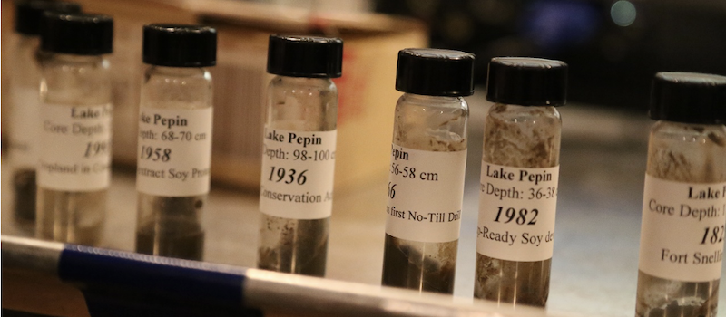
The science behind that answer is every bit as fascinating as the answer itself.
The answer isn't a single test. Instead, researchers have spent decades piecing together clues using several different scientific tools. Like detectives solving a mystery, each method answers a different question. Together, they reveal the story of how sediment moves through the watershed.
One of the first clues comes from the bottom of Lake Pepin itself.
As sediment settles to the lakebed, it forms layers that preserve a history of the watershed, much like the rings of a tree record years of growth. By collecting long sediment cores, researchers can reconstruct Lake Pepin's history over long periods of time. Those cores revealed that Lake Pepin began filling with sediment about ten times faster following European settlement and continue to provide an invaluable record of how the watershed has changed over time.
Knowing that more sediment was reaching the lake led naturally to another question: Where was it coming from?
To answer that, researchers turned to a technique known as sediment fingerprinting. Different soils and geologic materials contain unique combinations of minerals and naturally occurring elements. Those subtle differences act much like fingerprints, allowing scientists to compare sediment collected in rivers and Lake Pepin with samples collected from different parts of the watershed. In some studies, researchers analyzed more than 40 different elements, including rare earth elements, a group of naturally occurring metals found in rocks and soils, to compare the chemical "fingerprints" of sediment from different parts of the watershed.
Some of the most surprising clues came from an unexpected source: the Cold War.
If one is old enough, they may remember watching atomic test blasts that were on broadcast TV. I recall watching the many huge explosions that took place mainly in the 4 Corners part of the U.S. where there was not much beside desert and forbidding landscapes, perfect for test nuclear blasts that destroyed most everything in the test area. During atmospheric nuclear weapons testing in the late 1940s and early 1950s, tiny amounts of radioactive material were carried around the globe before settling back to Earth in rain and dust. Scientists soon realized this worldwide fallout had unintentionally created a timestamp within the landscape. Surface soils accumulated these radioactive isotopes over time, while soil buried several feet below the surface did not.
The Case of the Dueling Scientists
Two well-respected scientists did “studies” on the sediment entering Lake Pepin and came up with differing findings. One scientist asserted that most of the sediment was coming from streambank erosion because the Minnesota River is flowing through a geologically young landscape, cutting away the landscape. FARMLAND EROSION WAS NOT THE MAJOR SOURCE OF SEDIMENT.
Using the sediment fingerprinting previously discussed, another scientist asserted that the radioactive particles deposited on farmland got into Lake Pepin via the Minnesota River THROUGH FARMLAND EROSION. The work of the scientist who disavowed the presence of farmland erosion as a major sediment contributor was paid for by grants from Minnesota Corn Growers. At that time the MCG did not want to own up to the erosion problem! Thankfully attitudes have changed.
That difference became an invaluable scientific tool. Sediment eroded from farm fields carries much of this fallout signature because it comes from the land surface. Sediment eroded from streambanks, bluffs, and ravines often contains much less because it originates from older soils that have remained buried for decades — or even centuries. By measuring isotopes such as Cesium-137 and naturally occurring Lead-210, researchers can distinguish between these different sediment sources. Significant farmland erosion was indicated by the presence of atmospheric depositions of atomic particles in lake bottom sediment layers.
Like any good detective story, no single clue solves the mystery. Sediment cores reveal how Lake Pepin has changed over time. Sediment fingerprinting helps identify where that material originated. Together, these complementary approaches have transformed our understanding of how sediment moves through the Minnesota River Basin and continue to guide efforts to better understand, and ultimately reduce the sediment reaching Lake Pepin. These studies inform farmers that soil-conserving measures are needed to keep the precious resource-our soil where it will assure that productive agriculture can continue into the future.